Four papers published in the Journal of Volcanology and Geothermal Research in November 2009 explore the effects of the plume on western U.S. geodynamics, the structures of the lithosphere, earthquakes, and earthquake hazards.
|
Four papers published in the Journal of Volcanology and Geothermal Research in November 2009 explore the effects of the plume on western U.S. geodynamics, the structures of the lithosphere, earthquakes, and earthquake hazards. |
|
|||||||||||||||||||||||||||||||||||||||||||||||||||||||||||||||||||||||||||||||||||||||||||||||||||||||||||||||||||||||||||||||||||||||||||||||||||||||||||||||||||||||||||||||||||||||||||||||||||||||||||||||||||||||||||||||||||||||||||||||||||||||||||||||||||||||||||||||||||||||||||||||||||||||||||||||||||||||||||||||||||||||||||||||||||||||||||||||||||||||||||||||||||||||||||||||||||||||||||||||||||||
Published in Journal of Volcanology and Geothermal Research in November 2009
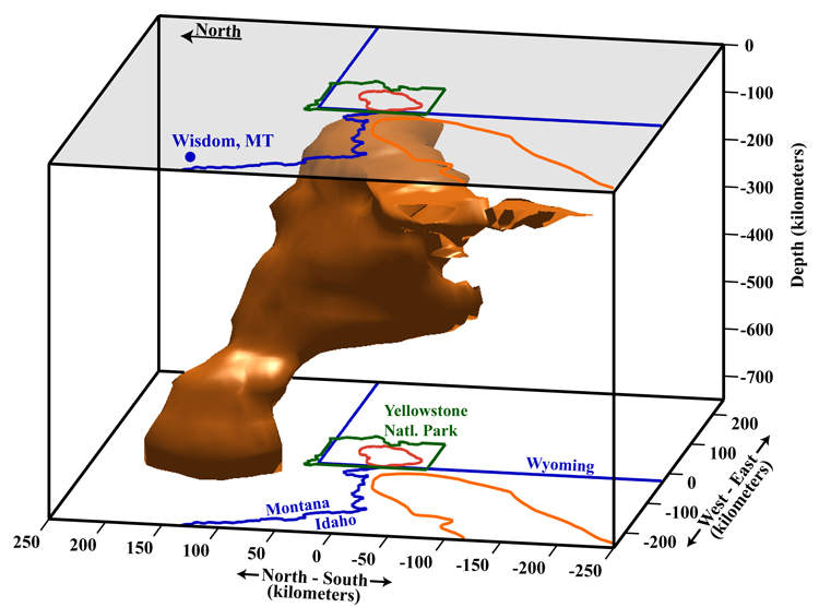
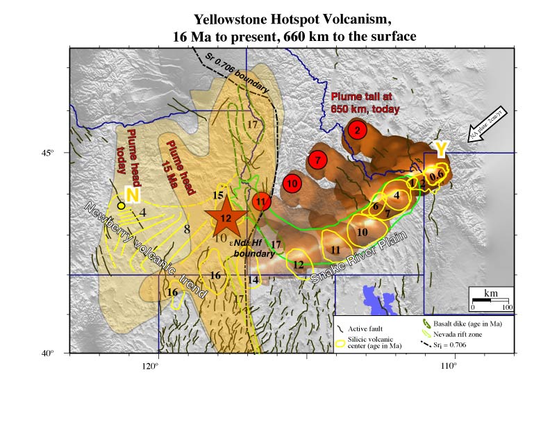
The Yellowstone plume has been tomographically imaged as a tilted body extending from 80 km depth at the Yellowstone Plateau to 660 km depth beneath western Montana. Geodynamic modeling of the plume finds that the plume is up to 120 K hotter than the surrounding mantle, with a maximum of 2.5% melt and a small buoyancy flux of 0.25 MG/s, properties of a cool, weak plume. Mantle flow modeling is used to constrain the evolution of the hotspot: the Yellowstone plume initially ascended vertically through the mantle beneath the thin, accreted lithosphere of the Columbia Plateau and was responsible for the 17 Ma flood basalts there. At 12 Ma, the plume passed beneath the thicker North American lithosphere and became entrained in eastward upper mantle return flow, resulting in a shift of volcanic activity to the southeast and the onset of rhyolitic eruptions caused by melting in the lithosphere. As the North America plate moved southwest, hotspot volcanism propagated northeast, and the resulting tectonic and magmatic interactions produced the 700-km-long Yellowstone-Snake River Plain magmatic system.
More Information: |
|
||||||||||||||||||||||||||||||||||||||||||||||||||||||||||||||||||||||||||||||||||||||||||||||||||||||||||||||||||||||||||||||||||||||||||||||||||||||
Published in Journal of Volcanology and Geothermal Research in November 2009
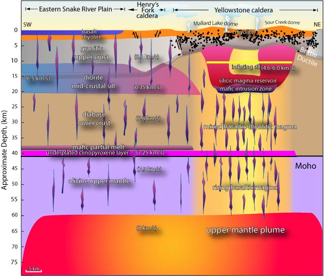
The structure and composition of the Yellowstone-Snake River Plain (YSRP) were modeled from gravity data, with additional constraints from other geophysical data. Strength profiles were also calculated at selected locations. Results from the modeling suggest that the lower crust of the eastern Snake River Plain (ESRP) has been thickened by underplating with a layer of clinopyroxene. A mid-crustal sill of variable thickness of 4 to 11 km and consisting of inter-fingering gabbroic lenses extend along the length of the ESRP and are the crystallized remains of former magma reservoirs. A low-density magma reservoir was modeled beneath the Yellowstone caldera and extending laterally 20 km northeast of the caldera boundary, resulting in a larger body than that imaged by tomography by about 20%. Strength models show that the YSRP crust becomes stronger and cooler with increasing distance from the Yellowstone caldera, where earthquakes are limited to shallow depths of 4-6 km and limited in maximum magnitude to less than M6.5.
More Information:
|
|
||||||||||||||||||||||||||||||||||||||||||||||||||||||||||||||||||||||||||||||||||||||||||||||||||||||||||||||||||||||||||||||||||||||||||||||||||||||
Published in Journal of Volcanology and Geothermal Research in November 2009
About 40% of the total seismicity in Yellowstone occurs as distinct clusters of events defined as earthquake swarms. Sixty-nine independent earthquake swarms were identified in the Yellowstone catalog from 1984-2006 based on inter-event times and spatial clustering. The swarms varied in duration from 1 to 46 days with the number of events varying from 30 to 722 with magnitudes of -1.2 to 4.8. Inspection of the frequency-magnitude distribution of earthquakes shows a range of b-values from 0.6 ± 0.1 to 1.5 ± 0.05. The highest values (1.5 ± 0.05) are associated with the youthful Mallard Lake resurgent dome. These variations are interpreted to be related to variations in stresses accompanying the migration of magmatic and hydrothermal fluids. An area of low b-values (0.6 ± 0.1) south of the Yellowstone caldera is interpreted as evidence of a relatively higher stress regime associated with an area of dominantly extensional focal mechanisms.
More Information:
|

|
||||||||||||||||||||||||||||||||||||||||||||||||||||||||||||||||||||||||||||||||||||||||||||||||||||||||||||||||||||||||||||||||||||||||||||||||||||||
Published in Journal of Volcanology and Geothermal Research in November 2009
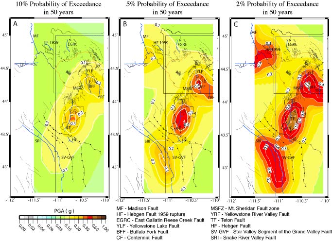
Probablistic seismic hazards were estimated for the Yellowstone and Teton regions using new, more accurately located earthquake catalogues, geologic fault slip rates, and background earthquake occurrence rates. The new earthquake catalogues were determined from three- dimensional seismic velocity models, resulting in more precise hypocenters. The results of the analysis reveal that the greatest hazards are associated with the Teton fault, which has a high slip rate of 1.3 mm/yr yet is seismically quiescent with diffuse earthquake distribution only in the southern Jackson Hole Valley and Gros Ventre Range. In Yellowstone, hazards are associated with the active earthquake zone between the Hebgen Lake fault zone and northern caldera boundary, as well as the Mt. Sheridan fault in southeast Yellowstone, which slip rates of 1.4 mm/yr. The Yellowstone-Teton region is among the regions of highest seismic hazard in the western U.S.
More Information:
|
|
||||||||||||||||||||||||||||||||||||||||||||||||||||||||||||||||||||||||||||||||||||||||||||||||||||||||||||||||||||||||||||||||||||||||||||||||||||||
Published in Journal of Geophysical Research in April 2009
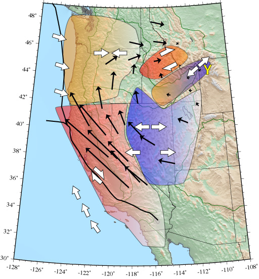
Contemporary deformation of the Yellowstone hot spot and surrounding western United States is analyzed using tectonic microplate modeling, employing constraints from GPS observations corrected for postseismic deformation of M7+ earthquakes, fault slip rates, and earthquake focal mechanisms. We focus primarily on the kinematics of the Yellowstone hot spot and the eastern Snake River Plain volcanic field (ESRP), and secondarily on Basin-Range and Columbia Plateau provinces. This study reveals that the overall motion of the western United States is characterized by clockwise rotation, with westward extension and northwest shear in the Basin-Range province, northeast to east contraction in the Columbia Plateau, and southwest extension of the Yellowstone - Snake River Plain block that is driven by the high gravitational potential of the Yellowstone swell.
More Information:
|
|
||||||||||||||||||||||||||||||||||||||||||||||||||||||||||||||||||||||||||||||||||||||||||||||||||||||||||||||||||||||||||||||||||||||||||||||||||||||
Published in Journal of Geophysical Research in April 2006
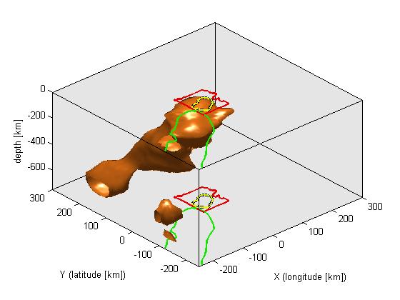
The development of the 16 Ma Yellowstone-Snake River Plain volcanic system has been attributed to the North America lithosphere moving over a stationary mantle plume, but the plume itself remained unresolved because of a lack of seismic data. New seismic data now provide strong evidence for an upper mantle plume to depths of 450 km below the Yellowstone caldera and eastern Snake River Plain. Distant earthquakes were recorded on two temporary seismograph arrays operated from 1999-2003 in 500x600-km area centered on Yellowstone and analysed to obtain a model of seismic velocities beneath Yellowstone. The tomographyic analysis revealed a body with anomalously low seismic velocities in the upper mantle that tilted 30°, so that the body becomes offset to the north with increasing depth. These results are consistent with an upwelling of hot material (i.e., a plume) in the upper mantle. Furthermore, the tilting of the plume is consistent horizontal flow of mantle material interacting with the plume.
More Information: |
|

|

|
||||||||||||||||||||||||||||||||||||||||||||||||||||||||||||||||||||||||||||||||||||||||||||||||||||||||||||||||||||||||||||||||||||||||||||||||||||||
Published in Science on November 09 2007
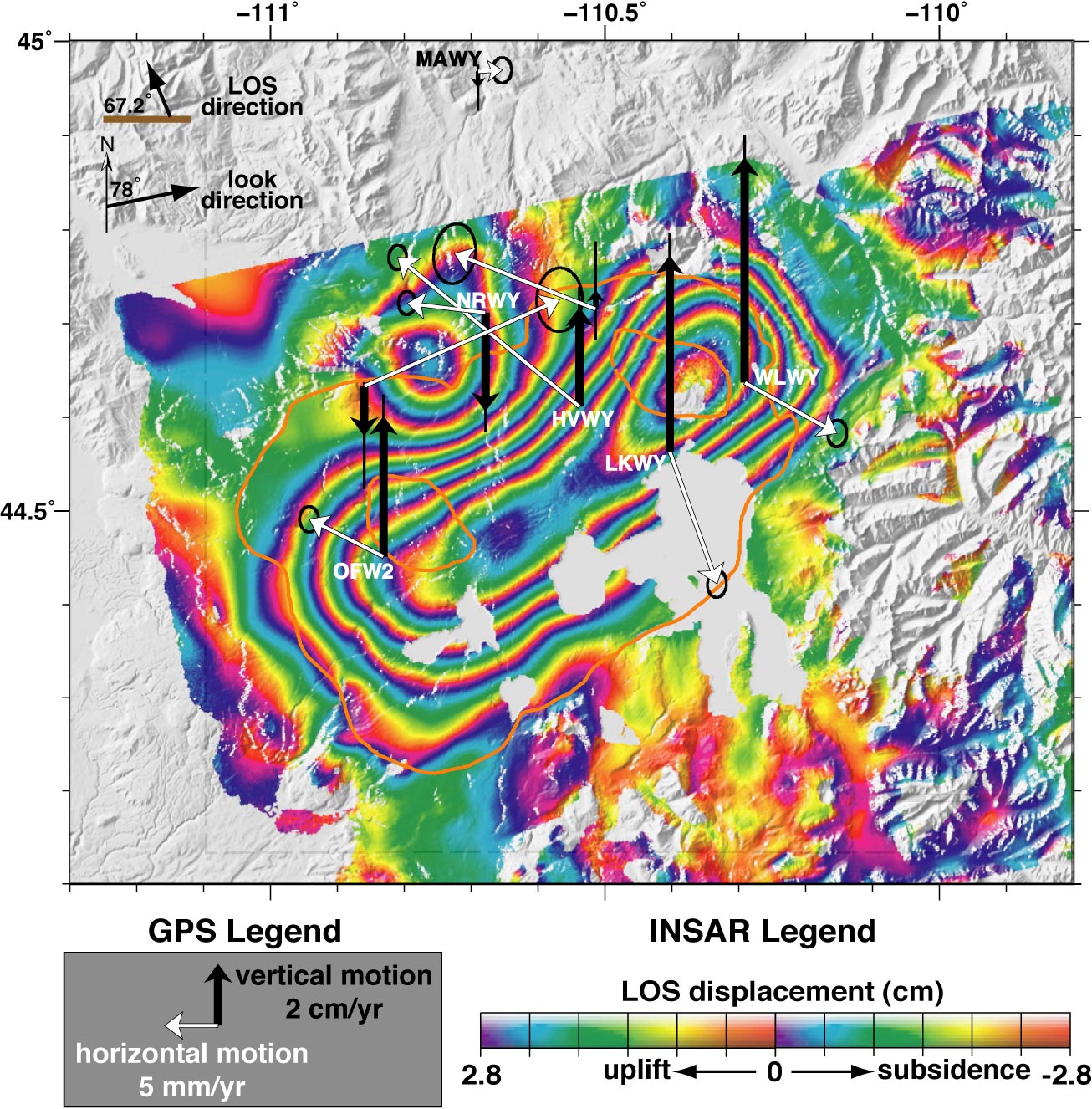
The Yellowstone caldera began an extraordinary episode of ground rising in mid-2004, revealed by GPS (Global Positioning System) and InSAR (Interferometric Synthetic Aperture Radar) measurements, at rates up to 7 cm/yr that is over three times faster than previously observed inflation rates. The caldera-wide accelerated uplift is interpreted as magmatic recharge of the Yellowstone magma body. While the geodetic observations and models do not imply an impending volcanic eruption or hydrothermal explosion, they are important evidence of on going processes of a large caldera that was produced by a super volcano eruption.
More Information:
|
|
|
||||||||||||||||||||||||||||||||||||||||||||||||||||||||||||||||||||||||||||||||||||||||||||||||||||||||||||||||||||||||||||||||||||||||||||||||||||||
Published in Journal of Geophysical Research in March 2007
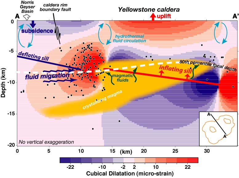
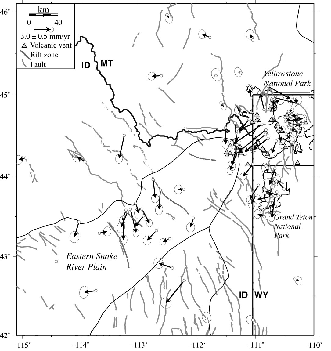
The University of Utah conducted seven GPS campaigns at 140 sites in the Yellowstone-Snake River Plain volcanic system between 1987 and 2003 and installed a network of 15 permanent stations. Analysis of the GPS measurements revealed periods of uplift and subsidence at the Yellowton caldera. From 1987 to 1995, the caldera subsided at a maximum rate of 14 mm/yr. From 1995 to 2000, the center of deformation shifted to the north caldera boundary, which rose at up to 15 mm/yr. Subsidence resumed in the the calder between 2000 and 2003 at 9 mm/yr, while uplift continued at the north caldera boundary at 12 mm/yr. These rates contrast are an order of magnitude less than the accelerated uplift, which began in 2004. The caldera deformation was hypothesized to arise from the accumulation and release of brines or other fluids from the magma chamber. The study additionally measured extension across the caldera at 2-4 mm/yr and southwest motion of the eastern Snake River Plain at 2.1 mm/yr.
More Information:
|

|
|
||||||||||||||||||||||||||||||||||||||||||||||||||||||||||||||||||||||||||||||||||||||||||||||||||||||||||||||||||||||||||||||||||||||||||||||||||||||
Published in Journal of Volcanology and Geothermal Research in March 2004
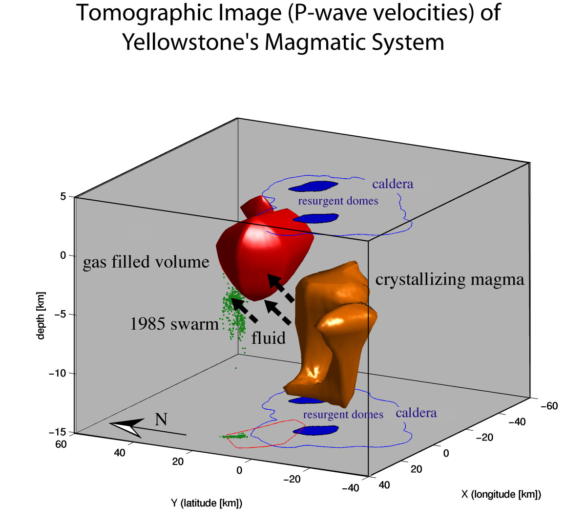
Local earthquake tomography was used to determine the P-wave and P-wave to S-wave velocity structure at Yellowstone National Park. A body with anomalously low P-wave velocities was found below the Yellowston caldera at depths greater than 8 km and interpreted to be a magma chamber of partially molten rock. Another anomaly of low Vp and Vp/Vs was found at shallow depths of 2 km at the northwest caldera boundary. This shallow anomaly is consistent with porous, gas-filled rock, with the gas probably being CO2. The release of magmatic fluids such as CO2 exsolved from the crystallizing magma may be associated with earthquake swarms in Yellowstone.
More Information:
|
|
||||||||||||||||||||||||||||||||||||||||||||||||||||||||||||||||||||||||||||||||||||||||||||||||||||||||||||||||||||||||||||||||||||||||||||||||||||||