Earthquakes Of Yellowstone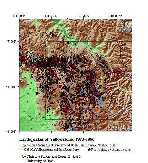 Bob Smith has conducted earthquake research in Yellowstone since 1970 and currently directs the Yellowstone seismic network (YSN). The YSN is operated cooperatively with the U.S. Geol. Survey Volcano Hazards program and the National Park Service and covers the seismically and volcanically active Yellowstone National Park and surrounding area. It is designed for the purpose of monitoring volcano and geyser-related earthquake activity and for studying the subsurface processes of Yellowstone. The earliest account of Yellowstone's earthquakes was given by Ferdinand Hayden (1872, 1873) based upon his late 19th century, pioneering field expeditions into Yellowstone. Hayden recognized that Yellowstone was the center of a giant volcanic system and remarked on the occurrence of numerous earthquakes that he and his colleagues felt:
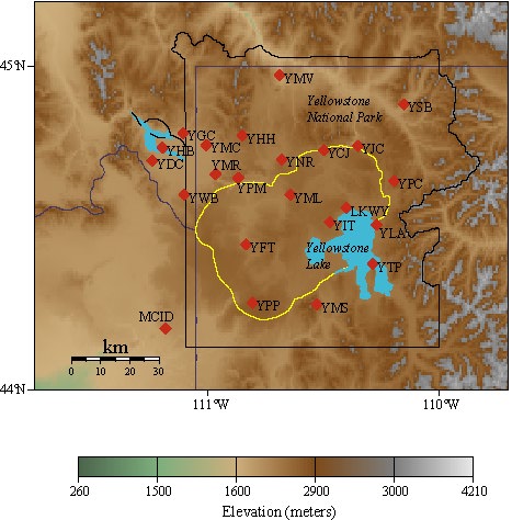
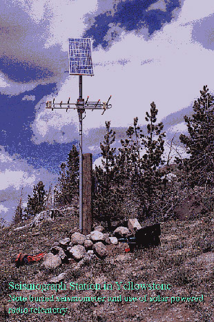
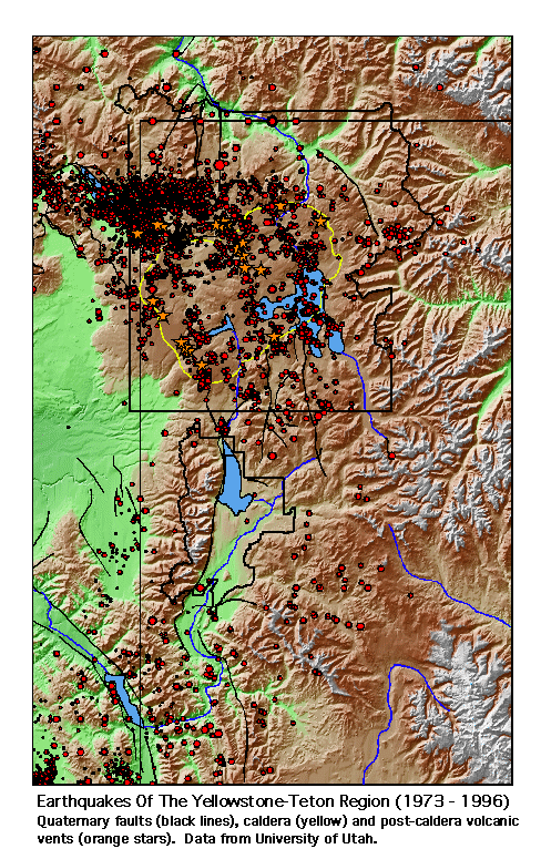
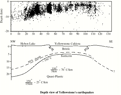
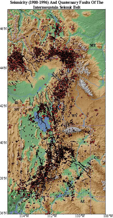
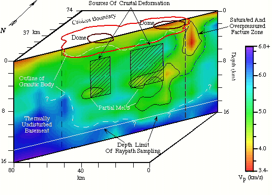
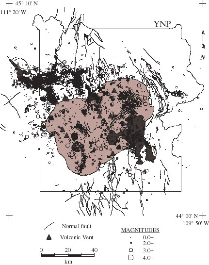
Hayden (1872). So persistent were earthquake tremors at Yellowstone Lake that Hayden named this camp "Earthquake Camp", an aptly named site as Yellowstone Lake has persisted as one of the most notable areas of earthquake swarms in the entire Yellowstone region. The Yellowstone seismograph network is operated by the University of Utah Seismograph Stations as part of our overall monitoring of the Intermountain Seismic Belt. Coverage of the YSN restricted to Yellowstone National Park and adjacent areas extending from latitude 44° 0' N to 45° 10' N, and from longitude 109° 45' W to 111° 30' W. See a seismic station map here as well as the status of the network here. Information on the network can be obtained by contacting the UUSS. Network HistoryThe U.S. Geological Survey (USGS) operated a telemetered seismic network in the Yellowstone area from 1972 through 1981. Data from the early network were recorded at the USGS, Menlo Park, California (primarily on 16-mm analog film recorders), and at Park Headquarters located at Mammoth, Wyoming (on tape recorders). The YSN did not operate during 1982 and 1983. In November 1983, digital computer recording of the Yellowstone network at the University of Utah was initiated through support of the USGS and the NPS. Complete maintenance and recording of the YSN was transferred to the UUSS in 1991. YSN Station Instrumentation, Telemetry and RecordingThe Yellowstone National Park seismograph network consists of a 22-station short-period, vertical-component network and broadband network. With support by the USGS Volcano Hazards project and the National Park Service, the University of Utah has upgraded the network over the past five years. The upgrade provides balanced geographic coverage with seismometers designed to be sensitive to volcanic processes. The instrumentation includes 3 three- component short-period stations, three broadband stations (Guralp 40Ts), and five new vertical-component stations to provide better caldera coverage. Telemetry and network reliability have been improved for the rugged, mountainous, winter environment. The YSN seismograph station map can be seen here. The data are centrally recorded in Salt Lake City by the University of Utah. The standard instrumentation at each field site consists of a vertical-component seismometer with a natural frequency of 1.0 Hz, an amplifier/voltage controlled oscillator (VCO) package, a 100-milliwatt radio transmitter, a 9 db gain directional Yagi antenna, and interfacing electronics powered by 12 volt batteries and solar electric panels. The central recording facility at the UUSS incorporates a bank of discriminators, a time code receiver, two drum recorders, a Concurrent Computer Corp. 7200-C data acquisition computer, and a distributed network of SUN workstations for data analysis. At each field site, the seismometer acts as a transducer to convert ground velocity to an electrical signal, which is amplified and converted into a frequency-modulated (FM) audio tone within the amplifier/VCO unit. Eight FM center frequencies ranging from 680 to 3060 Hz are in use with a 340 Hz separation between center frequencies and an individual fixed bandwidth of 250 Hz. Data from the YSN are transmitted continuously via either UHF or VHF analog radios to an FAA radar site located on Sawtelle Peak, Idaho. Signals are then multiplexed onto four FAA microwave lines for retransmission to the FAA control center in Salt Lake City, UT. From there, the data are transmitted to the University of Utah's central recording laboratory via four voice-grade telephone lines. Yellowstone Seismicity (after Smith and Arabasz, 1991).Earthquake epicenters in Yellowstone reveal a pattern of intense seismicity related to faults and volcanic features. Plotted here are Yellowstone's 1973-1996 earthquakes on digital topography showing their relation of epicenters to faults and post-caldera (post 631,000 year old) volcanic vents. Intense swarms of shallow earthquakes and occasional moderate-sized earthquakes as large as the MS = 6.1 earthquake in 1975 near Norris Junction, characterize the seismicity of Yellowstone. Norris also has the highest temperature hydrothemal system in the park. The geophysical evidence suggests that earthquakes of Yellowstone are influenced by the presence of magmas, partial melts, and hydrothermal activity at crustal depths from near surface to depths of ~5 km. Earthquakes occur on faults that form boundaries of small upper-crustal blocks and reflect a combination of deformation caused by local transport of magma and hydrothermal fluids as well as by the regional northeast extension superimposed from the Basin-Range tectonic stress field. Earthquakes reveal a pattern of seismicity over the Yellowstone-Hebgen Lake region that extends into the Yellowstone caldera along northwesting trending clusters of epicenters. Earthquakes extend ~25 km from Hebgen Lake, Montana, along an east-west trend into Yellowstone National Park where they take on a northwest trend along distinct seismic zones about 25 km long that cross the caldera boundary. Within the caldera, earthquakes have not exceeded magnitude MS = 5.0 and generally have scattered epicenters; in the western part of the caldera, northwest-trending clusters of epicenters, together with aligned volcanic vents, may be related to buried, but still active, Quaternary faults. In several cases, there are good correlations between earthquake swarms and major changes in hydrothermal activity. Local faulting along the west side of Yellowstone Lake has Holocene displacements and appears to be seismically active. Parts of the Gallatin and Teton normal fault systems, which generally have a northerly trends outside the Yellowstone region, presumably lie beneath the area now covered by the Quaternary volcanics of the Yellowstone Plateau. A broader view of Yellowstone seismicity and that of Teton region is shown here. Focal depths of earthquakes in Yellowstone reveal notable variations across the caldera that are related to variations in heat flux and rock composition. Maximum focal depths outside the caldera are generally less than 15 to 20 km, and mostly less than 5 km beneath the inner caldera. This pattern of earthquake- shallowing suggests a thin seismogenic brittle upper crust beneath the thermally active inner caldera. Rheologic models imply that below about 5 km, the crust is in a quasi-plastic, ductile state at temperatures in excess of 350°C - incapable of supporting large stresses. Note that the MS = 6.1 earthquake in 1975 occurred along the caldera's northwest boundary. On a regional scale, earthquakes are most intense on the west side of Yellowstone National Park. The most seismically active area is associated with the 1959, MS = 7.5, Hebgen Lake main shock that occurred within about 30 km of the northwestern side of the Yellowstone caldera. This large earthquake may have resulted from unusual lithospheric uplift and viscoelastic relaxation associated with the Yellowstone hotspot.Along the northwest side of the eastern Snake River Plain, earthquakes have a notable northwest alignment of epicenters in central Idaho, which is aftershock activity of the 1983, MS = 7.3, Borah Peak earthquake on the Lost River fault. This pattern contrasts with the scatter of what we have called background seismicity elsewhere in the central ISB. The "turning on" of earthquakes on the Lost River fault emphasizes the relative seismic quiescence of the neighboring Lemhi and Beaverhead faults to the northeast. All three faults are part of a domain of active, latest Quaternary basin-range normal faulting northwest of the SRP. Hence, the paucity of earthquakes between the Lost River fault and the Idaho-Montana border marks an important seismic gap in the central ISB. Seismic surveillance by the Idaho National Engineering Laboratory reveals few earthquakes within the Snake River Plain itself. The lack of earthquakes is thought to be related to increased crustal strength resisting earthquakes, to high temperatures that inhibit earthquakes, or to complex stresses related to the Yellowstone hotspot. Seismic Images Of Yellowstone's Underground By Tomographic ImagingStudies of Yellowstone's subsurface geology use seismic waves to illuminate its structure. This method is like that of a radiologist who studies the human body with X-rays. A recent study of the P and S velocity structure of Yellowstone from local earthquake and controlled source tomography by Miller and Smith (1997) revealed the P and S velocity (from Vp/Vs ratios) distribution and improved hypocenter locations for the Yellowstone volcanic field that shows strong evidence for crustal magma chambers. The cross section of velocity was determined from inversion of first arrival times from 7,942 local earthquakes and 16 controlled source explosions. The P wave velocity model has an rms of ± 0.09 sec., whereas the Vp/Vs ratio model (including S wave arrivals from 511 earthquakes) has an rms of ± 0.29 sec. High P and S velocities outside the Yellowstone caldera represent thermally undisturbed basement and sedimentary rocks. A caldera-wide 15% decrease from regional P velocities at depths of 6 km to 12 km is coincident with a 60 mGal negative gravity anomaly and is interpreted as a hot, subsolidus, granitic batholith with a quasi-plastic rheology. Localized 30% reductions from regional seismic velocities and higher Vp/Vs ratios 8 km beneath Yellowstone's resurgent domes are interpreted as partial melts and vestigial magma systems associated with youthful (less than 2 Ma) silicic volcanism. Additional low P and S velocities, low Vp/Vs ratios, and a 20 mGal gravity low less than 4 km beneath the northeast caldera rim are interpreted as a hydrothermal fracture zone thermally driven by underlying partial melt.Hypocenters relocated with the three-dimensional P velocity model reveal the dominant alignment parallel to NW-SE trending normal faults northwest of the caldera and post-caldera volcanic vents within the caldera. Average focal depths of the relocated earthquakes decrease from more than 11 km outside the caldera to less than 6 km within the caldera, reflecting thinning of the seismogenic crust and a concomitant increase in temperature that inhibits brittle fracture. | |